Live from our sensor network
Drone Detection as a Service
Detect the drones over your site — and where the pilot is.
Passive detection of DJI and Remote ID drones. Each alert shows the drone and, often from the very first detection, where the pilot is.
Where our network already reaches you, you go live without any installation. Where it does not, we provide the hardware at no extra cost.
Starting at 160€ per month
1195 DKK per month
75,900+
detections logged
8
countries on watch
- Pilot positionoften from the very first detection
- Purely passivethe pilot receives no signal
- Made in Denmarkby our own engineers in Odense
- Supported byESA BIC Denmark and EU co‑funding
How Drone Detection Works
From signal to alert in seconds, with nothing required from the drone.

Detect
Our scanners pick up Remote ID broadcasts and DJI DroneID RF signals from drones in range.

Locate
We identify the drone's model and serial, and pin the pilot's exact position, often from the very first detection.

Alert & log
You get an instant SMS or app notification, and every detection is logged to your dashboard.
Locating the pilot
Not just the drone: where the pilot is.
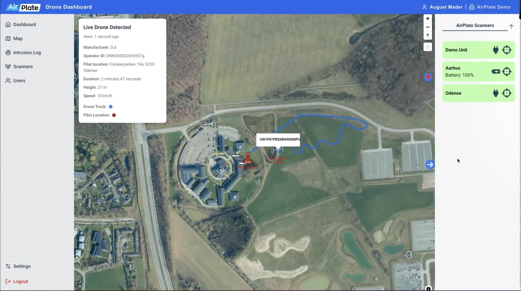
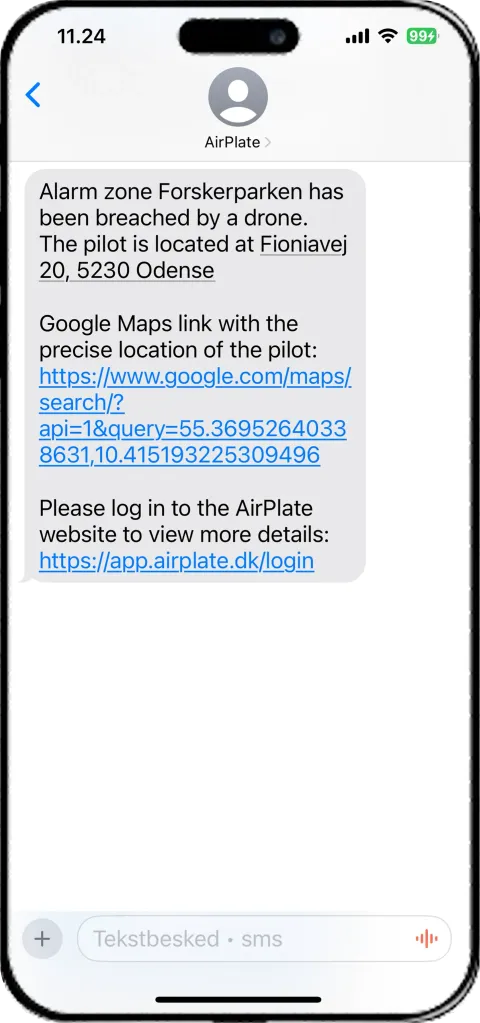
Each alert shows the drone and, often from the very first detection, where the pilot is.
- The drone's flight track and the pilot's position on one map
- An SMS with the pilot's street address and a Google Maps link
- The drone's model, serial, height and speed
One Operational Picture
Every drone detection, pilot position and alert, in a single dashboard.
Everything on One Dashboard
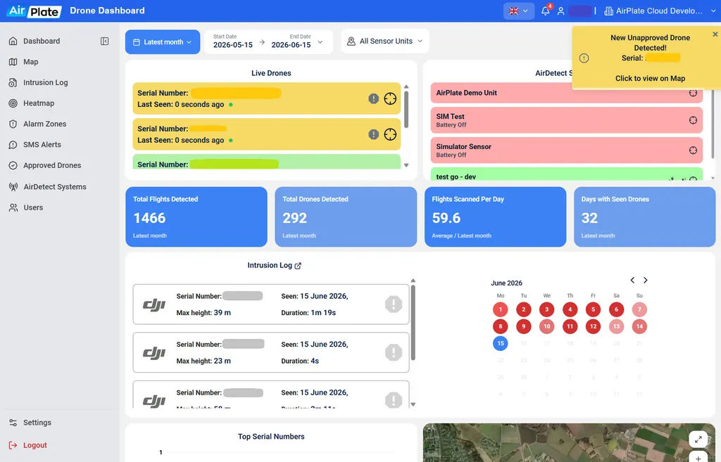
- One dashboard for live activity and full history
- Instantly track down detected drones
- See detection counts, trends and recent events
Hotspots at a Glance
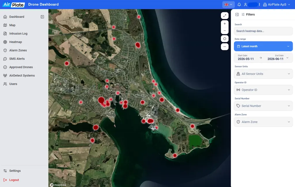
- A heatmap of where drones actually fly
- Recurring routes and patterns stand out instantly
- See which areas need the most attention
Your Zones, Your Rules
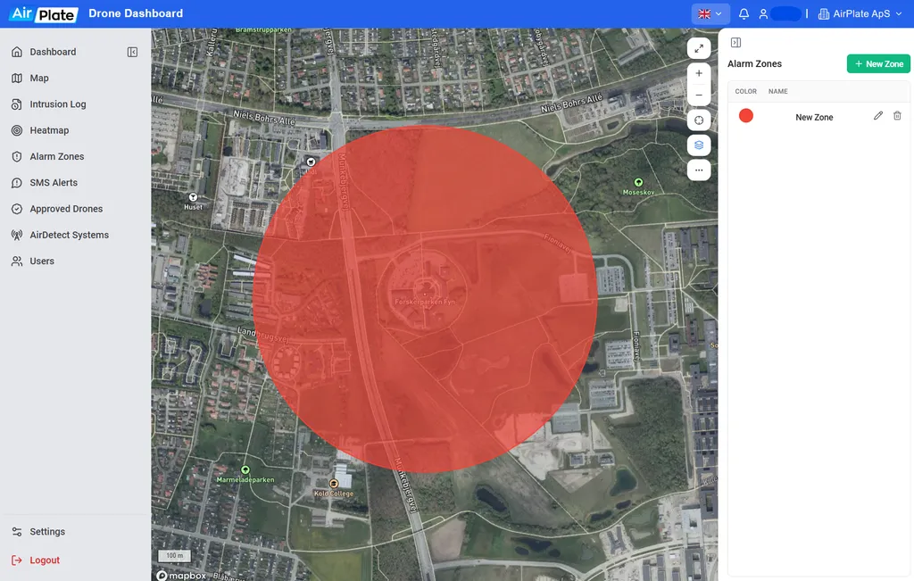
- Draw alarm zones around what matters most
- Any detection inside a zone triggers an alert
- Adjust your zones any time, in seconds
The Right People, Alerted Instantly
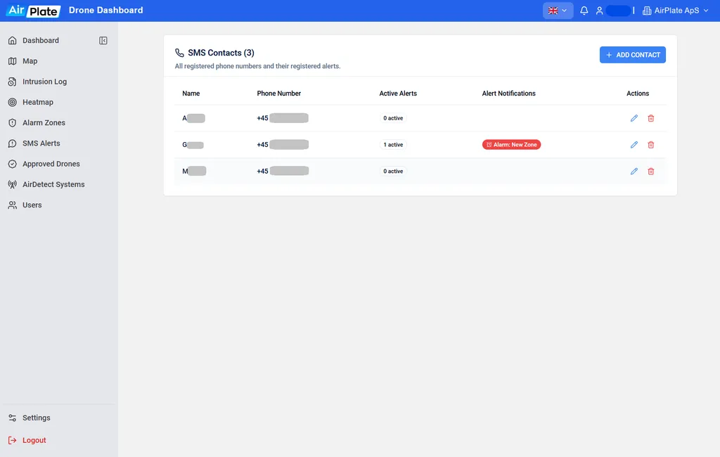
- SMS and app alerts the moment a drone appears
- Choose which contacts are notified per zone
- Real-time delivery, day and night
What the Drone Detection Service Covers

Mark Multiple Areas
Monitor multiple areas and detect drones at each location.
Live Pilot Position
Monitor live drones and pilot location in real time.
Intrusion Alerts
Receive SMS and email alerts for any detected intrusions.

Detailed Track Log
Review detected drones for intrusion evidence.

Data Analysis
Investigate drone activity through the dashboard.

Pilot Stays Unaware
Pilot remains unaware when detected.

E-mail reports
Receive a weekly summary of all registered drones.

Data Protection
No data shared with 
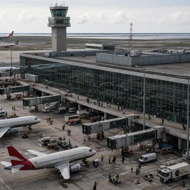
Protecting Against Drones Across Industries
One drone detection platform, many missions, wherever unauthorized drones are a risk.







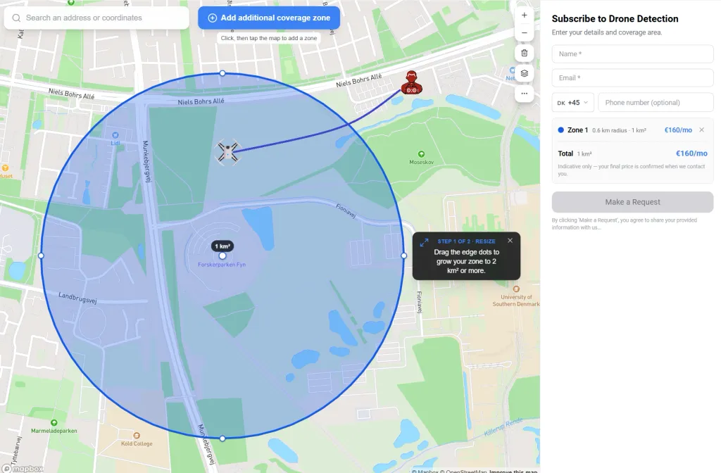
Estimate Your Coverage in 30 Seconds
- Draw the area you want covered on a live map
- Draw multiple zones and see indicative monthly prices per zone
- No commitment. We follow up with a tailored quotation
Starting at 160€ per month
1195 DKK per month
Which Drones We Detect
| Drone Models From |  |
| Commercial Drones Over 250g | |
| Remote ID Equipped Drones | |
| Detection Rate of All Drones |  |
| Daily Drones Seen Per Site |  |
| Military Drones |  |
| DIY Drones | |
Frequently Asked
Questions
What is the AirPlate Drone Detection Service?
It is drone detection as a service: you subscribe to drone detection data for your site and follow every detection in one dashboard, with pilot positions, instant alerts and a full activity log.
See how it worksHow does the drone detection work?
Detection is purely passive: nothing is required from the drone, and the pilot receives no signal. Each detection runs through three steps.
- Detect: the scanners pick up Remote ID broadcasts and DJI DroneID RF signals from drones in range.
- Locate: the drone's model and serial are identified, and the pilot's exact position is pinned, often from the very first detection.
- Alert and log: you get an instant SMS or app notification, and every detection is kept in the activity log.
Do I need to install anything?
Not where AirPlate's network already reaches your site: there you start without any installation. Where it does not, AirPlate provides the hardware at no extra cost.
Estimate your costWhich drones does the service detect?
DJI drone models, commercial drones over 250 g, and Remote ID equipped drones, with a stated detection rate of 90% across all drones. Military drones and DIY builds are not covered. You see the drone's model, serial, height and speed.
How are alerts set up?
You draw your own alarm zones, and any detection inside a zone triggers an alert. SMS and app alerts reach the right people the moment a drone appears.
- You can adjust the zones any time, and choose which contacts are notified for each zone.
- Alerts also come by email, and detection data can also feed your security operations dashboard.
- Hotspots are visible at a glance in the dashboard.
Is my detection data shared with anyone?
No. Your detection data stays in your AirPlate account, and nothing is shared with DJI or any other third party.
What does the Drone Detection Service cost?
It starts at 160 € (1195 DKK) per month. The estimator shows the price for the area you draw, before you commit to anything.
- Draw the area you want covered on the map. You can draw several zones.
- See an indicative monthly price for each zone, in about 30 seconds.
- Send your request, with no commitment. AirPlate follows up with a tailored quotation.
Ready to Secure Your Airspace?
Draw your area on the map and see your monthly price in about 30 seconds.
Starting at 160€ per month
1195 DKK per month